![]()
![]()
![]()
![]()
Back to
Cascades
main
page
"Mt. Baker" refers to a:
Community
Mountain
National Forest
Recreation Area
Scenic Highway
Ski Area
Volcano
Wilderness Area
Where to stay
and
what to do in
Mount Baker
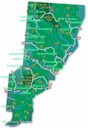
The town and road map of Washington's Cascades will help you locate cities, towns, attractions and points of interest.
Nearby Cities and Towns
Bellingham, 39 miles
Concrete, 68 miles
Glacier, 37 miles
Maple Falls, 30 miles
Sedro Woolley,
46 miles
More Cascades
North Cascades
Central Cascades
South Cascades
Mountain Passes
Blewett Pass
Snoqualmie Pass
Stevens Pass
White Pass
Name
In 1792 an English lieutenant by the name of Joseph Baker sighted the
mountain from the deck of Captain George Vancouver's sloop Discovery in the
Strait of Juan de Fuca. Captain Vancouver named the mountain in Lt. Baker's
honor.
Movies filmed at Mt Baker
The Call of the Wild (1935)
Also filmed along the banks of the North Fork Nooksack River. Starring Clark
Gable and Loretta Young.
Washington Travel Regions and Maps
Map
Cascade Mountains
Map
Northeast
Map
Northwest
Map
Olympic Peninsula
Map
Puget Sound
Map
San Juan Islands
Map
South Central
Map
Southeast
Map
Southwest
Mount Baker Area
Mount Baker the Volcano
Mount Baker is the most isolated of the Cascade volcanoes in the USA. It rests on a foundation of non-volcanic rocks in a region that is largely non-volcanic in origin. Since the last Ice Age, the area around the mountain has been largely ice free, but the mountain itself remains heavily mantled with snow and ice. After Mount Rainier, it is the most heavily glaciated of the Cascade volcanoes, the volume of snow and ice being greater than that of all the other Cascades volcanoes (except Rainier) combined. Due to its many glaciers, local Native Americans gave Mt. Baker a name meaning "White Steep Mountain." The present-day cone sits atop a similar older volcanic cone called Black Buttes volcano which was active between 500,000 and 300,000 years ago.
During the last 10,000 years there have been at least two or more lava flows, at least eight mudflows and a pyroclastic flow. Mount Baker erupted on several occasions during the 19th century, and its most prominent crater, Sherman Crater, may have formed in the 18th or early 19th century. Most hydrothermal activity at Mount Baker is concentrated within Sherman Crater. This activity, in the form of steam and flows of hot rock and gas, increased significantly in March 1975 and caused concern that an eruption might be imminent. The activity diminished somewhat by 1978. Mudflows remain the most likely hazard from the volcano. Avalanches of snow and rock debris from the rim of Sherman Crater have swept down Boulder Glacier at least six times since 1958.
Elevation
10,778 feet (3,285 meters)
Getting to Mt Baker
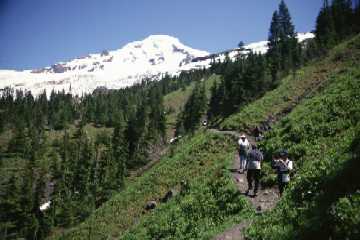
Road
The best view of the mountain is from the Glacier Creek Road off of Highway
542. A 10-kilometer hike, taking off from Dead Horse Road (No.3907) affords
closer views of Baker's north side. On the south side of the mountain Forest
Service Road 372, taking off from Baker Lake Road, ends near the Schreibers
Meadow cinder cone.
![]()
Go Northwest!
Bookstore
Best selection of books on the Northwest.
Click here!
 Active
Volcanoes: Mount Vesuvius, Mount Fuji, Mount St. Helens, Surtsey, Mount
Baker, Mount Ruapehu, Hekla, Popocatepetl, Mauna Loa by Wikipedia. This
book contains articles from Wikipedia and other free sources on active
volcanoes around the world including Mount Baker.
Order now...
Active
Volcanoes: Mount Vesuvius, Mount Fuji, Mount St. Helens, Surtsey, Mount
Baker, Mount Ruapehu, Hekla, Popocatepetl, Mauna Loa by Wikipedia. This
book contains articles from Wikipedia and other free sources on active
volcanoes around the world including Mount Baker.
Order now...
 A
Falcon Guide to the Mount Baker-Mount Shuksan Area (Exploring Series) by
Mike McQuaide. Written by an outdoor expert, this guide explores Mount Baker,
Mount Shuksan and the surrounding area with detailed maps, facts about the
area, routes, trail descriptions and more.
Order now...
A
Falcon Guide to the Mount Baker-Mount Shuksan Area (Exploring Series) by
Mike McQuaide. Written by an outdoor expert, this guide explores Mount Baker,
Mount Shuksan and the surrounding area with detailed maps, facts about the
area, routes, trail descriptions and more.
Order now...
 The
Mt. Baker Book by Paul W. Hodge. This book is a photographic guide to
the features of Mount Baker in the North Cascades. Included is information on the lakes, rivers,
streams, peaks and glaciers, trailheads, campgrounds and guides to the roads is included.
Order now...
The
Mt. Baker Book by Paul W. Hodge. This book is a photographic guide to
the features of Mount Baker in the North Cascades. Included is information on the lakes, rivers,
streams, peaks and glaciers, trailheads, campgrounds and guides to the roads is included.
Order now...
We appreciate your orders. They help keep
Go Northwest! online.
Northwest Books
from . . .
![]()
Shopping at
Go Northwest!
![]()
![]()
![]()
![]()