![]()
![]()
![]()
![]()
Back to
Whidbey Island
main page
VISITOR INFORMATION
Getting There
Web Sites
More Whidbey Island
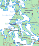
The Whidbey Island Map will help you locate cities, towns and highways.
Nearby Cities and Towns
Clinton, 18 miles
Coupeville, 10 miles
Freeland, 9 miles
Greenbank, 3 miles
Langley, 18 miles
Oak Harbor, 20 miles
Cities and Towns
of Puget Sound
Washington State Ferry Service
Schedules
Route Map
Weather
Washington Travel Regions and Maps
Map
Cascade Mountains
Map
Northeast
Map
Northwest
Map
Olympic Peninsula
Map
Puget Sound
Map
San Juan Islands
Map
South Central
Map
Southeast
Map
Southwest
Whidbey Island, Washington
Visitor Information
Getting to Whidbey Island
From Seattle Area: Take I-5 North to the Mukilteo/Clinton ferry landing (Exit 189). Follow signs for "Whidbey Island Ferry". When nearing the landing, watch for and enter the right hand ferry holding lane. The line of cars can be long, but move quickly. The lane leads to a ticket booth at the entrance to the large ferry loading parking lot. Boats depart every 30 minutes for the 15-minute crossing to Clinton, the southern-most community on Whidbey Island.
From Olympic Peninsula: Take the 30-minute ferry ride from Port Townsend to Keystone, which is about four miles south of Coupeville.
Southbound from From points North follow I-5 south to State Route 20, follow signs to Whidbey Island/Deception Pass State Park, continue south.
From Bellingham and other points north: Follow I-5 south to Burlington and exit west on State Route 20. Follow SR 20 (watch for signs reading "Whidbey Island/Deception Pass State Park") to Whidbey Island.
Related Web Sites
Clinton Ferry Cam
Four webcam views of the Clinton Ferry Landing and nearby areas.
Experience Washington by Washington Tourism Alliance
Whidbey and Camano Islands
This "Tourist Attractions" page by the Island Web, lists over 25
attractions, such as Grasser's Lagoon and Kettles Trail Park, as found on
the two Islands. The listing has short descriptions of each attraction and
all are clearly located on the accompanying map. Return to the Island Web
home page for links from Whidbey Net (below).
Whidbey Island
Washington
South Whidbey Island WA Visitor's Guide, Business Directory and Community
Home Page.
Whidbey Net
This links to the Visitors section of this ISP's web site. Includes map and
information on the Island County's parks, events, scenic sights,
accommodation and restaurants.
Go Northwest!
Bookstore
Best selection of books on the Northwest.
Click here!
 Benchmark
Washington Road & Recreation Atlas, 6th Edition by Benchmark Map.
Field-checked Landscape Maps(tm) show complete road detail. The revised
recreation guide is organized by categories such as attractions and activities.
The metro map section covers the greater Seattle-Tacoma area.
Order now...
Benchmark
Washington Road & Recreation Atlas, 6th Edition by Benchmark Map.
Field-checked Landscape Maps(tm) show complete road detail. The revised
recreation guide is organized by categories such as attractions and activities.
The metro map section covers the greater Seattle-Tacoma area.
Order now...
 The
Natural History of Puget Sound Country by Arthur R. Kruckeberg. The
history of the Puget Sound begins with how ice ages and vulcanism shaped
the land plus information on the flora, fauna and the climate.
Order now...
The
Natural History of Puget Sound Country by Arthur R. Kruckeberg. The
history of the Puget Sound begins with how ice ages and vulcanism shaped
the land plus information on the flora, fauna and the climate.
Order now...
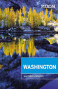 Moon
Washington, 11th Edition (Moon Handbooks) by Matthew Lombardi. This
travel writer and Seattle resident gives an insider's view of everything
the Evergreen State has to offer such as great places to eat, scenic
drives and volunteer vacations. Discover Seattle's arts and culture,
details on climbing Mt Rainier and so much more.
Order now...
Moon
Washington, 11th Edition (Moon Handbooks) by Matthew Lombardi. This
travel writer and Seattle resident gives an insider's view of everything
the Evergreen State has to offer such as great places to eat, scenic
drives and volunteer vacations. Discover Seattle's arts and culture,
details on climbing Mt Rainier and so much more.
Order now...
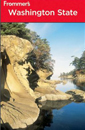 Frommer's Washington State,
7th Edition by Karl Samson. This expert author tells you where to find great places to stay in every price range,
the best outdoor recreation and much more. Utilize the planning tools to
maximize your next adventure in the Evergreen State.
Order now...
Frommer's Washington State,
7th Edition by Karl Samson. This expert author tells you where to find great places to stay in every price range,
the best outdoor recreation and much more. Utilize the planning tools to
maximize your next adventure in the Evergreen State.
Order now...
We appreciate your orders. They help keep
Go Northwest! online.
Northwest Books
from . . .
![]()
Shopping at
Go Northwest!
![]()
![]()
![]()
![]()