![]()
![]()
![]()
![]()
Where to stay and
what to do in
Whidbey Island, Washington
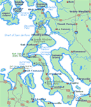
The Whidbey Island Map will help you locate cities, towns and highways.
Nearby Cities and Towns
Clinton, 18 miles
Coupeville, 10 miles
Freeland, 9 miles
Greenbank, 3 miles
Langley, 18 miles
Oak Harbor, 20 miles
Cities and Towns
of Puget Sound
Washington State Ferry Service
Schedules
Route Map
Weather
Washington Travel Regions and Maps
Map
Cascade Mountains
Map
Northeast
Map
Northwest
Map
Olympic Peninsula
Map
Puget Sound
Map
San Juan Islands
Map
South Central
Map
Southeast
Map
Southwest
Puget Sound Washington Travel Region
Whidbey Island
Pamper yourself at one of Whidbey Island's luxurious bed & breakfasts (see "Accommodations") or take your camping gear to one of the state parks (see "Attractions") and experience for yourself this retreat popular with local Puget Sounders. In addition to offering a laid-back atmosphere and romantic get-away-accommodations, Whidbey Island also is in the "rain shadow" of the Olympic Mountains and receives half the annual rainfall of Seattle.
Narrow country roads winding through farmland allow for a relaxing drive and welcome respite from the freeways of the mainland. Small towns and villages offer pleasant shops, casual browsing and good food. State parks provide easy access to outdoor activities and scenic views of Puget Sound and distant mountains.
History buffs will note that Whidbey Island has long been viewed as a key defense site. There are military relics from other eras, including 19th century blockhouses originally built to protect against Native American attack, concrete bunkers from World War II, as well as today's Naval Air Station Whidbey, which is in operation near Oak Harbor. While soaking up the history, stretch your legs with a seven mile hike along the shoreline from Fort Casey to Fort Ebey.
For more information on Whidbey Island, see individual cities and towns:
- Clinton
- Coupeville
- Freeland
- Greenbank
- Langley
- Oak Harbor
Also, see listings under:
Whidbey Island also can provide an enjoyable route to other destinations. You will find excellent ferry connections to Seattle, the Olympic Peninsula and the Olympic Mountains. Or, drive north and cross the beautiful and dramatic Deception Pass onto Fidalgo Island and visit the city of Anacortes. There, you can catch a ferry to the San Juan Islands, or, take time out to enjoy the city's many shops, galleries and other attractions. You also can head east on State Route 20 to Interstate 5 and take the freeway to either Vancouver, British Columbia or to Seattle. Otherwise, stay on Highway 20 and follow it to the North Cascades National Park and other recreational areas of the Cascade Mountains.
|
Weather
|
The Puget Sound map will help you locate cities, towns and other attractions. |


Go Northwest!
Bookstore
Best selection of books on the Northwest.
Click here!
 Moon
Washington, 11th Edition (Moon Handbooks) by Matthew Lombardi. This
travel writer and Seattle resident gives an insider's view of everything
the Evergreen State has to offer such as great places to eat, scenic
drives and volunteer vacations. Discover Seattle's arts and culture,
details on climbing Mt Rainier and so much more.
Order now...
Moon
Washington, 11th Edition (Moon Handbooks) by Matthew Lombardi. This
travel writer and Seattle resident gives an insider's view of everything
the Evergreen State has to offer such as great places to eat, scenic
drives and volunteer vacations. Discover Seattle's arts and culture,
details on climbing Mt Rainier and so much more.
Order now...
 Frommer's Washington State,
7th Edition by Karl Samson. This expert author tells you where to find great places to stay in every price range,
the best outdoor recreation and much more. Utilize the planning tools to
maximize your next adventure in the Evergreen State.
Order now...
Frommer's Washington State,
7th Edition by Karl Samson. This expert author tells you where to find great places to stay in every price range,
the best outdoor recreation and much more. Utilize the planning tools to
maximize your next adventure in the Evergreen State.
Order now...
We appreciate your orders. They help keep
Go Northwest! online.
Northwest Books
from . . .
![]()
Shopping at
Go Northwest!
![]()
![]()
![]()
![]()