![]()
![]()
![]()
![]()
Where to stay and
what to do in
Kalispell
ACCOMMODATIONS
Bed and Breakfast
Cabins and Cottages
Campgrounds/RV Parks
Hotels and Motels
Vacation Rentals
FOOD AND BEVERAGE
Bakeries
Coffee and Espresso
Fast Food
Pizza
Pubs, Taverns and Bars
Restaurants and Cafes
VISITOR INFORMATION
Getting There
Click on Flathead Valley Area Map to locate cities and towns and other features of the Flathead Valley in Northwest Montana.
Nearby Cities and Towns
Bigfork - 18.3 miles
Columbia Falls- 15.6 miles
Coram - 25.4 miles
Hungry Horse - 22.4 miles
Lakeside - 14.7 miles
Somers - 9.7 miles
Whitefish - 15 miles
Cities and Towns of Flathead Valley

The relief map of Northwest Montana will help you locate geographical features such as rivers and mountains.
More Northwest Montana
Bitterroot Valley
Blackfeet Indian Res.
Clark Fork River
Flathead Valley
Kootenai Valley
Missoula Valley
Seeley Swan Valley
Montana Travel Regions and Maps:
Map
North Central
Map
Northeast
Map
Northwest
Map
South Central
Map
Southeast
Map
Southwest
Kalispell, MT
Kalispell, located seven miles northwest of Flathead Lake and 31 miles southwest of Glacier National Park, serves as the center point to some of Northwest Montana's best recreational opportunities. There are more than 10,000 square miles of parks and national forests scattered throughout Northern Montana's Rocky Mountains. Situated just south of the town of Whitefish, Kalispell is bordered on the west by the Kootenai National Forest and on the east by the Flathead National Forest. Both are known for their glacier-carved mountains and inviting beauty.
Established in the early 1890s as a result of railway expansion, Kalispell enjoyed a moderate growth throughout the 1900s, serving as the commercial center for much of the county. Since 2000 however, the city has more than doubled in size and now benefits from a flourishing art community with more than two dozen art galleries and studios spread throughout the city. Antique stores and gift shops offer additional opportunity for shopping. The city features two museums: the Hockaday Museum of Art, featuring exhibits, lectures, classes and events year-round and the 1894 Central School Museum, Kalispell's first school, which now serves as an historical museum.
Accommodations include bed and breakfasts, cabins, campgrounds, hotels and motels, RV parks and vacation rentals. State parks feature camping and RV facilities, and there are additional private lodges and RV parks within an easy commute of Kalispell.
Located at the northwest tip of the state, Kalispell is intersected by US 2 and US 93 and lies 7 miles from Glacier International Airport, the region's major airfield. Interstate 90 is the city's closest interstate and is approximately 100 miles south of the city.
*See the Go Northwest! guide to the Flathead Valley.
|
Weather
|
Click on the town and road map to locate cities, towns and attractions. |

Go Northwest!
Bookstore
Best selection of books on the Northwest.
Click
here!
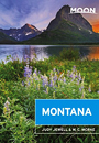 Moon Montana,
9th Edition (Moon Handbooks) by Judy Jewell and W.C. McRae. This guide
has complete information about all of Big Sky Country, from Yellowstone
National Park to the eastern prairies of the state, to help the traveler
plan a memorable vacation.
Order now...
Moon Montana,
9th Edition (Moon Handbooks) by Judy Jewell and W.C. McRae. This guide
has complete information about all of Big Sky Country, from Yellowstone
National Park to the eastern prairies of the state, to help the traveler
plan a memorable vacation.
Order now...
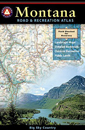 Benchmark
Montana Road & Recreation Atlas by Benchmark Maps. Large-scale Landscape
MapsTM and a complete 30-page Recreation Guide make it the ideal planning
tool for any outdoor adventure. Benchmark field-checkers drove thousands of
miles to make sure the Montana Road & Recreation Atlas is the most accurate
and reliable map product.
Order now...
Benchmark
Montana Road & Recreation Atlas by Benchmark Maps. Large-scale Landscape
MapsTM and a complete 30-page Recreation Guide make it the ideal planning
tool for any outdoor adventure. Benchmark field-checkers drove thousands of
miles to make sure the Montana Road & Recreation Atlas is the most accurate
and reliable map product.
Order now...
 Montana
Curiosities: Quirky Characters, Roadside Oddities & Other Offbeat Stuff, 2nd Edition
by Ednor Therriault. This guide highlights the most
offbeat and oddest people, places, and events of the Treasure State. This
book is in full color and features maps so you can easily locate the state's
quirky destinations.
Order now...
Montana
Curiosities: Quirky Characters, Roadside Oddities & Other Offbeat Stuff, 2nd Edition
by Ednor Therriault. This guide highlights the most
offbeat and oddest people, places, and events of the Treasure State. This
book is in full color and features maps so you can easily locate the state's
quirky destinations.
Order now...
We appreciate your orders. They help keep
Go Northwest! online.
Northwest Books
from . . .
![]()
Shopping at
Go Northwest!
![]()
![]()
![]()
![]()