![]()
![]()
![]()
Where to stay and
what to do in
Darby
ACCOMMODATIONS
Bed & Breakfast
Cabins & Cottages
Campgrounds
Hotels & Motels
Inns & Lodges
RV Parks
Vacation Rentals
More Bitterroot Valley
Darby
Hamilton
Stevensville
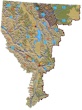
The relief map of Northwest Montana will help you locate geographical features such as rivers and mountains.
More Northwest Montana
Bitterroot Valley
Blackfeet Indian Res.
Clark Fork River
Flathead Valley
Kootenai Valley
Missoula Valley
Seeley Swan Valley
Montana Travel Regions and Maps:
Map
North Central
Map
Northeast
Map
Northwest
Map
South Central
Map
Southeast
Map
Southwest
Northwest Montana Travel Area
Darby, Montana
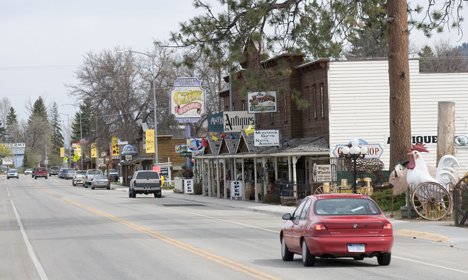
Darby, located on U.S. Highway 93 at the sound end of the Bitterroot Valley, is a community of about 750 people offering accommodations and access to the many recreational opportunities that abound in the Bitterroot National Forest.
Explore Darby in more detail by clicking through the pages listed below and the links they provide to more detailed descriptions and presentations:
ACCOMMODATIONS
*See also the Go Northwest! guide to the Bitterroot Valley
|
Weather
|
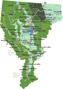
Click on the town and road map to locate cities, towns and attractions. |

Go Northwest!
Bookstore
Best selection of books on the Northwest.
Click
here!
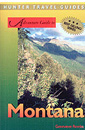 Montana
Adventure Guide by Genevieve Rowles. Offering coverage of the history,
culture, geography and climate, this book also looks at wilderness trips in
Montana, USA. Areas featured include Flathead and Clearwater Mountains, and
fly-fishing, Nordic skiing, rock-hounding and overnight hiking excursions
are all covered.
Order now...
Montana
Adventure Guide by Genevieve Rowles. Offering coverage of the history,
culture, geography and climate, this book also looks at wilderness trips in
Montana, USA. Areas featured include Flathead and Clearwater Mountains, and
fly-fishing, Nordic skiing, rock-hounding and overnight hiking excursions
are all covered.
Order now...
 Montana
Off the Beaten Path, 9th Edition: A Guide to Unique Places by Ednor
Therriault and Michael McCoy. Discover hidden attractions, unusual
locales, unique finds and quirky cultural tidbits; all the interesting
stuff you'd want to see and experience if you only knew about them.
Order now...
Montana
Off the Beaten Path, 9th Edition: A Guide to Unique Places by Ednor
Therriault and Michael McCoy. Discover hidden attractions, unusual
locales, unique finds and quirky cultural tidbits; all the interesting
stuff you'd want to see and experience if you only knew about them.
Order now...
 Benchmark
Montana Road & Recreation Atlas by Benchmark Maps. Large-scale Landscape
MapsTM and a complete 30-page Recreation Guide make it the ideal planning
tool for any outdoor adventure. Benchmark field-checkers drove thousands of
miles to make sure the Montana Road & Recreation Atlas is the most accurate
and reliable map product.
Order now...
Benchmark
Montana Road & Recreation Atlas by Benchmark Maps. Large-scale Landscape
MapsTM and a complete 30-page Recreation Guide make it the ideal planning
tool for any outdoor adventure. Benchmark field-checkers drove thousands of
miles to make sure the Montana Road & Recreation Atlas is the most accurate
and reliable map product.
Order now...
We appreciate your orders. They help keep
Go Northwest! online.
Northwest Books
from . . .
![]()
Shopping at
Go Northwest!
![]()
![]()
![]()
![]()